Garmin GPSMAP® 65 Daudzfrekvenču pārnēsājamā navigācijas ierīce


Apraksts
FIND YOUR WAY IN THE BIG WIDE WORLD
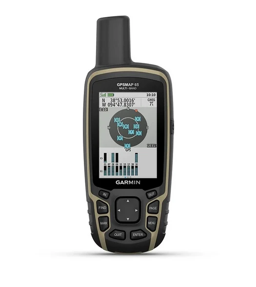
Discover more with this rugged handheld device with a 2.6-inch color display and preloaded maps, ensuring optimal tracking accuracy.

STAY ON TRACK
EXPANDED SATELLITE NAVIGATION NETWORK SUPPORT
Multi-band technology and expanded GNSS support (GPS, GLONASS, Galileo, QZSS and IRNSS) ensure optimal accuracy in mountainous areas, among urban high-rises and in dense forests.
PRELOADED TOPOACTIVE EUROPE MAPS
Preloaded TopoActive Europe maps clearly show routable streets, trail networks, water bodies, natural features, land parcel status, buildings and more.

SMART NOTIFICATIONS
Receive emails, text messages and alerts directly on your handheld device by pairing it with a compatible device.

MICROSD™ SLOT
Using a compatible device and a microSD memory card, you can easily download maps and see public land types and boundaries, as well as private landowner names and their parcel boundaries.
GEOCACHES
Automatically receive geocache (treasure) updates from Geocaching Live – including descriptions, logs, and hints.
GARMIN EXPLORE APP
Plan, view, and sync waypoints, routes, and tracks. Review your completed activity before you even get home.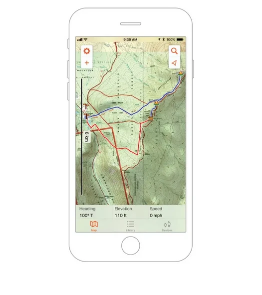
Technical specifications:
General | |
| Lens material | Chemically strengthened glass |
|---|---|
| Physical dimensions | 6.1 x 16.0 x 3.6 cm |
| Weight | 217 g with batteries |
| Water resistance rating | IPX7 |
| Display type | Semi-transparent, 65K color TFT |
| Display size | 3.6 x 5.5 cm; 2.6-inch diagonal (6.6 cm) |
| Display resolution | 160 x 240 pixels |
| Battery type | 2 AA batteries (not included); NiMH or lithium batteries recommended |
| Battery life | 16 hours |
| Memory / history | 16 GB (user-available space depends on loaded maps) |
| Interface | Compatible with high-speed mini USB and NMEA 0183 |
Maps and memory | |
| Preloaded maps | Yes (TopoActive Europe; suitable for routing) |
|---|---|
| Ability to add maps | Yes |
| Basemap | Yes |
| Automatic route calculation (turn-by-turn road navigation) | Yes |
| Map segments | 3000 |
| BirdsEye | 250 BirdsEye image files |
| Ir detalios hidrogrāfijas funkcijas (piekrastes, ezera / upes krasti, mitrāji un pastāvīgas un sezonālas straumes) | Jā |
| Iekļautas apskates vietas (parki, kempingi, skatu punkti un piknika vietas) | Jā |
| Rāda nacionālos, valsts un vietējos parkus, mežus un dabas teritorijas | Jā |
| Krātuve un barošanas jauda | Jā (maks. 32 GB microSD™ kartīte) |
| Maršruta punkti / izlase / vietas | 5000 |
| Trases | 200 |
| Pēdu žurnāls | 10 000 punktu, 200 saglabātas trases |
| Maršruti | 200, 250 punkti vienam maršrutam; 50 punkti, automātiski veidojot maršrutus |
Sensori | |
| GPS | Jā |
|---|---|
| GLONASS | Jā |
| Galileo | Jā |
| QZSS | Jā |
| Augstas jutības uztvērējs | Jā |
| GPS kompass (kustībā) | Jā |
| Vairākas frekvenču joslas | Jā |
Ikdienas viedās funkcijas | |
| Viedie paziņojumi rokā nēsājamās ierīcēs | Jā |
|---|---|
| VIRB® kameras tālvadības pults | Jā |
| Saderība ar Garmin Connect™ Mobile | Jā |
Āra izklaides funkcijas | |
| Navigācija no punkta uz punktu | Jā |
|---|---|
| Vietas aprēķināšana | Yes |
| Fishing forecast | Yes |
| Sun and moon information | Yes |
| Geocaching friendly | Yes (electronic) |
| Compatible with custom maps | yes (500 custom map slices) |
| Image viewer | Yes |
Apps used in the field | |
| Compatible with the Garmin Explore™ app | Yes |
|---|---|
| Compatible with the Garmin Explore website | Yes |
Contacts | |
| Wireless connectivity | Yes - Bluetooth®, ANT+® |
|---|---|
Specifikācijas
- Svars
- 0.29 kg
- Zīmols
- Garmin


